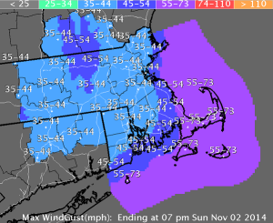
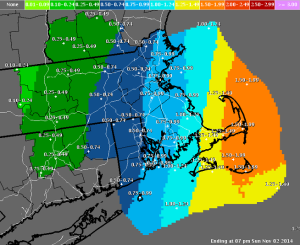
National Weather Service is forecasting a coastal storm today into tomorrow with strong to damaging winds, minor coastal flooding in East Coastal Massachusetts with potential pockets of moderate coastal flooding, and heavy rainfall in Eastern New England with the possibility of precipitation ending as a brief period of light, wet snow. Main storm impacts are expected late today through tomorrow morning.
Winds
The strongest winds will occur Saturday evening into Sunday along the coast and in the interior on Sunday, with wind gusts of 40 to 50 mph, and possible gusts of 50 to 60 mph gusts across Cape Cod and Nantucket. Impacts include downed trees, tree limbs, and isolated power outages. Leaves on trees may exacerbate the problem.
Watches and Warnings
· A High Wind Watch for coastal Plymouth county, the Cape and Islands is in effect from 4:00 p.m. today through 5:00 p.m. tomorrow for sustained winds of 30-40 MPH with gusts to 60 MPH.. Eastern MA has been issued for the potential of northerly 50 to 60 mph wind gusts Saturday afternoon into Sunday morning.
· A Wind Advisory is in effect from 6:00 p.m. today through 8:00 a.m. tomorrow for Middlesex County, the remainder of Plymouth County, Suffolk County, Bristol County, Essex County, Norfolk County.
· A Coastal Flood Watch is in effect from 6:00 p.m. through 9:00 a.m. tomorrow for the Eastern MA coast and Nantucket. Highest risk area is in Scituate and Hull MA.
· A Storm Watch for the waters east of Massachusetts today into tomorrow for the potential of storm force gusts up to 50 knots and 20+ foot seas. 


